

Most Popular Destinations

Mana Pools is home to a wide range of mammals and over 350 species of birds.

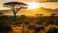
MANA POOLS
Mana Pools National Park is a World Heritage Site based on its pure wilderness and beauty. It is home to a wide range of mammals, over 350 bird species.
Mana Pools National Park is unique, great for walking and canoeing safaris to view the abundant wildlife, including a healthy elephant population.
Situated in the northern region of Zimbabwe, on the southern banks of the Zambezi River, Mana Pools National Park will leave you breathless with its beauty. Mana Pools is a wildlife-rich, biodiverse wonderland that will delight at every turn.You can expect to spot hippopotamus, crocodile, elephants and a wonderful array of aquatic birds and there’s a good chance of seeing lioness’ hunting around waterholes, where prey are seemingly easy pickings.


KARIBA
Lake Kariba is the world's largest artificial lake and reservoir by volume. It lies 1,300 kilometres upstream from the Indian Ocean, along the border between Zambia and Zimbabwe.
Kariba dam is not only the largest manmade lake in the world but it is also an oasis for tourism for both Zambia and Zimbabwe. Its capacity is not only centered on tourism but extends to supplying hydroelectric power to both Zambia and Zimbabwe.
Many people visit Kariba briefly as a stopping off point prior to setting out from one of its four main harbours on boats across the lake either to stay in the safari and fishing camps on the southern shore mainland, in the Matusadona National Park or on the islands, or to spend a few tranquil days fishing, game veiwing.


CHIRUNDU
The Zambezi is the fourth-longest river in Africa, the longest east-flowing river in Africa and the largest flowing into the Indian Ocean from Africa. Its drainage basin covers 1,390,000 km², slightly less than half of the Nile's.
The Zambezi River is Southern Africa's , River of Life.
It drains seven countries and supports millions of people, who make use of its rich fisheries, forests, water, and rich floodplain soils.
Over two million years ago, the Upper Zambezi used to flow through what is now the Makgadikgadi Pan in Botswana. However, as a result of tectonic uplift, a vast lake was formed, and the river shifted eastwards – dividing the Limpopo and Zambezi rivers.
Chirundu is the border town between Zimbabwe and Zambia with a new one-stop border control and customs and facility based on the Zimbabwe side of the Zambezi River.
Chirundu is mainly known for its Popular tiger fishing and boating location, exquisite sun sets and bird life, Wildlife such as hippos, crocodiles and elephants.


HWANGE NATIONAL PARK
Hwange National Park is the largest and most popular park in Zimbabwe. It offers excellent wildlife viewing, and most big safari animals can be seen, including the Big Five. Hwange is most known for the impressive concentration of elephant that are attracted to the park's waterholes during the dry season.
It was founded about 1900 after the discovery of coal in the vicinity and was named for a local chief, Whanga, who was the dynastic head of the Abananza people.
When it comes to size, Hwange is not only Zimbabwe’s largest national park, but at 14,651-square kilometres (5,656-square miles), it’s also one of the 10 largest parks in Africa.
Hwange National Park is home to the “Presidential Herd” of elephants. At an estimated 40,000 strong, it’s one of the largest herds on the continent.


MATOBA HILLS
Experience an exhilarating rhino tracking expedition, as the Matobo National Park is home to these massive creatures, part of the renowned Big Five. Scale granite hills of historical significance within a UNESCO World Heritage Site, uncovering ancient rock paintings that provide glimpses into the past. Pay homage to Cecil John Rhodes’ grave, a figure of historical significance. Visiting Matopos promises a thrilling adventure infused with rich history.
Just another world heritage site among many others in Zimbabwe situated a short distance from Bulawayo, Matobo National Park is the country’s oldest national park. One of it’s sublime features is the Matopo Hills a series of granite kopjes (rock formations) wooded valleys formed over 2 billion years ago.
Forty thousand years ago the caves and crevices carved out of these rocks became home to Zimbabwe’s earliest inhabitants, the “San”. Twenty thousand years later “San” artists began painting on the walls of caves and rock shelters, using special pigments and natural minerals that have survived the onslaught of climate and time.
In addition the recreational are includes World’s view , a scenic viewpoint and the burial of Cecil John Rhodes .The wildlife includes leopards both black rhinos and white rhinos.


VICTORIA FALLS
Victoria Falls Zimbabwe is one of the exquisite seven wonders of the world.
The Zambezi River is the fourth-largest in the African continent and spans across six different nations – its amazing journey spans an impressive 2,700 km. Along the way, you can see a range of wildlife and participate in a plethora of activities. Victoria Falls is the boundary dividing the upper and middle parts of the Zambezi. 75% of the Falls can be seen from the Zimbabwean side, while the remaining 25% is visible from the Zambian side.
500 million litres of water cascade every minute, the numbers almost seem too impossible to imagine! That’s the equivalent of 200 Olympic-sized swimming pools, to put things into perspective. It flows at a rate of 1088m3/s.
On the Zimbabwe side of the Falls you will find the Victoria Falls Rainforest, which is the only place on earth to see rain every single day of the year. The rains bless the area with lush greenery in the forest.


GREAT ZIMBABWE RUINS
The ruins of Great Zimbabwe were designated a United Nations Educational, Scientific and Cultural Organisation (UNESCO) World Heritage Site in 1986.
Great Zimbabwe consists of several sections. The first section is the Hill Complex,The Hill Complex is the oldest part of Great Zimbabwe, and shows signs of construction that date to around 900 C.E.
The second section, The Great Enclosure is a walled, circular area below the Hill Complex dating to the 14th century. The walls are over 9.7 meters (32 feet) high in places, and the enclosure’s circumference is 250 meters (820 feet).
The third section is the Valley Ruins. The Valley Ruins consist of a significant number of houses made mostly of mud-brick (daga) near the Great Enclosure. The distribution and number of houses suggests that Great Zimbabwe boasted a large population, between 10,000–20,000 people.


GONAREZHOU
Gonarezhou was originally established in 1936, as a protected game reserve. In 1975 it was proclaimed a National Park. The park was kept closed to the public during the Rhodesian bush war and Mozambique civil war, only re-opening in 1994.Between 1994 and 2007, it was wholly managed by the Zimbabwe Parks and Wildlife Management Authority (ZPWMA).
It has a true wilderness feeling which is why we love this National Park.The name Gonarezhou is attributed to the elephant populations found there. In Shona, 'nzou' or 'zhou' is the word for elephant. Gonarezhou is translated as "place of many elephants", and with eleven thousand plus elephants in the area, the name is quite fitting.


IMIRE CONSERVATION
Imire is dedicated to protecting wildlife and strongly believe that rural communities and conservation programmes can successfully thrive side by side, working together to ensure the protection of our natural heritage. Our vision at Imire is to enhance the relationships between tourism, conservation programmes and community areas through long-term, sustainable environmental management and positive community projects.
Imire creates awareness internationally of the wildlife and poaching crisis which threatens Zimbabwe and Africa, and the obstacles faced by local communities and conservation organisations. The biggest threats to the animals protected at Imire, and regionally are poaching and human overpopulation. Poaching is driven by demand for ivory and rhino horn in foreign countries, and fueled by poverty and lack of education on the ground. To protect the rhino and all wildlife, we believe we need to empower local communities.


BVUMBA MOUNTAINS
The Bvumba Mountains or Vumba Mountains straddle the Zimbabwe-Mozambique border, and are situated some 10 km south east of Mutare. The Bvumba rise to Castle Beacon at 1,911 metres, and are, together with the Chimanimani Mountains to the south and Nyanga Mountains to the north, part of the Eastern Highlands of the Manicaland and adjacent Manica provinces.
They are referred to as the "Mountains of the Mist" (Bvumba being the Shona word for "mist"), as so often the early morning starts with a mist which clears by mid-morning. Although lying mostly within Zimbabwe, the mountains extend north-eastward to Mount Vumba in Mozambique. They are capped by cool, green hills which shelter country hotels. The mountains are also known for their coffee plantations.
Is this Zimbabwe’s best-kept secret? The eastern highlands, and Vumba Mountains especially, are referred to as a World of Wonder. We decided to go see for ourselves – and found that the evergreen forests and mist belt have much to offer.


NYANGA NATIONAL PARK
Nyanga is located in the Manicaland province of Zimbabwe close to the Mozambique border. The closest large city to here would be Mutare.
Primarily a tourist town, Nyanga offers a variety of activities to visitors from fishing to golfing and mountain hikes. Historically the area is rich in Stone Age and Iron Age archaeological remains such as stone forts, pathways and other structures. Nyanga actually holds the most extensive artefact collection and stone structures in Africa.
With the main gate to the Nyanga National Park just a few kilometres out of the town, this is the perfect stop-over to explore the surroundings. Best seen as part of a Safari or group tour, Nyanga is suitable to visit at any time of year.


